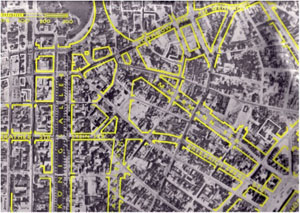
1. Destruction and reorganization of the city after WWII: New traffic routes, easier traffic regulations and a car-friendly city
 Click image to enlarge
Source: photographer unknown, date unknown, Traffic Management Department of the state capital Düsseldorf.
Questions
Answers
- The new traffic routes are broader, they abolish the old structure.
- Easier access to the feeder road and infrastructure (railway).
- More traffic >>> more noise and pollution because of individual traffic, traffic jams.


Presentation
The yellow marks in the aerial photo of Düsseldorf city (late 1940s) show the plans of the 1950s. To manage the city traffic the roadway ‘Berliner Allee’ – an extension of the ‘Corneliusstraße’ (in this picture still called ‘Parallelstraße’) was built (picture 1). This axis became the central point of the reorganization of the destroyed inner city, followed by other streets that run parallel to the ‘Königsallee’. In the north there is an allocation – east of the ‘Jan-Wellem-Platz’, which connected the north and the south of Düsseldorf with the main station (1955-1962).