2. Rome, a network
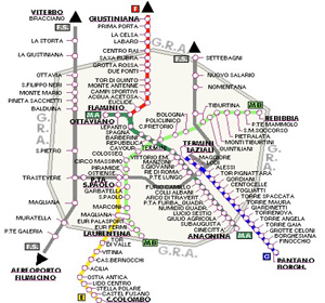
2a. Network of the underground of Rome
Questions 2a
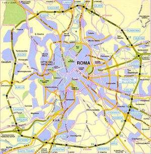
2b. Urban area of Rome

Questions 2b
Answers 2a
- The literal translation would be "a great connection ring" but this term will find its equivalent in each country: in France, it is rather a “périphérique”. The regional railways are a Y-shaped network which extends throughout the Roma area with lines along which the stations are farther apart than those of the underground.
- The network of the Roman underground crosses two main lines in X in the center of the city and they are divided from the terminal stations of Termini Laziali, Flaminio and San Paolo to better serve certain areas in the periphery of the center (southward to Laurentina station, and south-east to the Anagnina). But it is a highly centralized system on the station Termini, in contact with the ancient Roman center, and leaving many neighborhoods to regional services, resulting from the organization of the lines of the underground. This network appears less dense and interconnected than is the underground in Paris and it serves much less the periphery than does the underground in London.
Answers 2b
- The large ring road encircles the Roman settlement about 10 kilometers of a center located approximately at the Coliseum.
- The peripheral ring surrounding a heterogeneous agglomeration juxtaposing highly urbanized areas and large empty ones. The buildings are compact in the center, in the space corresponding to ancient Roma and eastward of the Coliseum is a succession of several neighborhoods separated by parallel boulevards. North and west urbanization grows in bands more or less guided by the axes of transport while in the south, a great less built area indicates other occupations (including the airport). Compared to Paris and London, the urban area of Roma - paradoxically - maintained natural spaces I in the center of town and did not grow preferably along the river banks. All these elements suggest a discontinuous growth and little control of that city.
- As we used to say "all roads lead to Rome" but we find that they have not all retained their former importance if we are to judge by the modest contemporary ways Pisana, Boccea or Nomentana. The peripheral position of major interchanges and major radial ways (yellow) suggests that relations are now the most intense from the north to the port of Ostia, that is to say along the Tiber valley and especially to the south-east, wide open on the south Italy of which Roma is the front door.
- There is only one ring on the edge of downtown, near the western half of the Roman settlement but at least three in the neighborhoods of the east side of the Coliseum . This indicates that urban growth has been more consistent and better organized eastward where a probably less strong dynamism of industrial and commercial settlements has been replaced by the expression of residential choices.


